

Deforestasi hulu dan lonjakan kehilangan hutan Aceh 2024–2025Upstream deforestation and Aceh's 2024–2025 forest-loss surge
Data 1995–2025, dengan lonjakan pada 2025Data from 1995 to 2025, with a surge in 2025
Menyusutnya tutupan hutan di daerah tangkapan air menjadi tekanan dinamis utama di balik besarnya dampak banjir 2025. Yayasan Auriga Nusantara mencatat deforestasi Aceh naik dari 8.962 hektare pada 2024 menjadi 38.157 hektare pada 2025, sementara Yayasan HAkA mencatat kehilangan tutupan hutan 39.687 hektare pada 2025. Sebagian besar angka 2025 adalah akibat bencana itu sendiri; argumen kausalnya bertumpu pada komponen antropogenik dan akumulasi kehilangan bertahun-tahun sebelumnya.
Shrinking forest cover in water catchments was the main dynamic pressure behind the severity of the 2025 floods. Yayasan Auriga Nusantara recorded Aceh's deforestation rising from 8,962 hectares in 2024 to 38,157 hectares in 2025, while Yayasan HAkA recorded 39,687 hectares of forest-cover loss in 2025. Most of the 2025 figure was caused by the disaster itself; the causal argument rests on the human-driven component and on losses accumulated over preceding years.
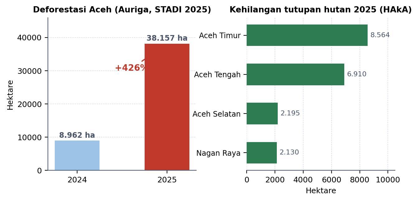
Laporan Status Deforestasi Indonesia 2025 dari Yayasan Auriga Nusantara, dirilis 31 Maret 2026, menyebut lonjakan deforestasi Aceh sebesar "426 persen". Bilangan itu sesungguhnya rasio 4,26 kali lipat; sebagai kenaikan, besarannya sekitar 326 persen. Yayasan HAkA, dengan konsep kehilangan tutupan hutan yang lebih luas, mencatat 10.610 hektare pada 2024 dan 39.687 hektare pada 2025. Kedua seri tidak dapat dipertukarkan: deforestasi mengukur hilangnya hutan alam secara permanen, sedangkan kehilangan tutupan mencakup pula tegakan di luar hutan alam dan kehilangan sementara.
Komposisi sebabnya menentukan cara membacanya. Menurut HAkA, sekitar 61,5 persen kehilangan 2025 tergolong akibat faktor alam, yakni longsor, banjir, dan pelebaran alur sungai, yang sebagian besar terpantau pada November–Desember 2025. Komponen antropogenik meliputi ekspansi perkebunan sekitar 13.000 hektare, pembukaan jalan 1.007 hektare, tambang 796 hektare, dan penebangan selektif 428 hektare. Karena itu angka 2025 tidak dapat dipakai sebagai bukti bahwa deforestasi tahun itu memicu bencana; bukti kausalnya adalah kehilangan antropogenik dan akumulasi 90.108 hektare sepanjang 2015–2024. Pemantauan Januari–September 2025 juga menunjukkan kehilangan di dalam Kawasan Ekosistem Leuser sudah melampaui total 2024 sebelum Senyar terbentuk.
Sebarannya menunjuk ke hulu: 71 persen kehilangan 2025 berlangsung di dalam Kawasan Ekosistem Leuser, sekitar 80 persen di dalam kawasan hutan, dan hutan lindung menanggung kehilangan terbesar, sedangkan pembukaan oleh manusia paling luas berada di areal penggunaan lain. Pola ini menandai dua kegagalan berbeda: lemahnya perlindungan kawasan lindung dan permisifnya izin alih fungsi di luar kawasan hutan. WALHI menambahkan ketimpangan laju: sekitar 15.000 hektare hilang per tahun berhadapan dengan kemampuan reboisasi sekitar 785 hektare per tahun.
Seluruh angka ini berasal dari penafsiran citra satelit oleh lembaga independen. Luasan relatif kukuh, sedangkan atribusi sebab bersifat estimatif dan tidak dapat membedakan kehilangan legal dari yang melanggar hukum.
Dalam angka absolut, faktor alam menyumbang 24.372 hektare, ekspansi perkebunan mencakup sekitar 32,8 persen kehilangan, dan kehilangan di dalam Kawasan Ekosistem Leuser mencapai 28.012 hektare. Lima kabupaten dengan kehilangan terbesar, yakni Aceh Timur, Aceh Tengah, Gayo Lues, Bener Meriah, dan Aceh Utara, menanggung sekitar 71 persen dari total, sementara Aceh Selatan menempati urutan teratas untuk kehilangan akibat faktor antropogenik. Titik tekanan utamanya meliputi Rawa Singkil, Peudada, Rawa Tripa, Seunagan–Beutong, Kapa Seusak, dan Birem Bayeun.
Yayasan Auriga Nusantara's Indonesia Deforestation Status 2025 report, released on 31 March 2026, described Aceh's deforestation surge as "426 per cent". That figure is in fact a ratio of 4.26; expressed as an increase it is about 326 per cent. Yayasan HAkA, using the broader concept of forest-cover loss, recorded 10,610 hectares in 2024 and 39,687 hectares in 2025. The two series are not interchangeable: deforestation measures permanent loss of natural forest, while cover loss also includes stands outside natural forest and temporary loss.
The breakdown of causes determines how the data should be read. According to HAkA, about 61.5 per cent of 2025 loss was due to natural factors, namely landslides, floods and channel widening, mostly observed in November–December 2025. The human component comprised plantation expansion of about 13,000 hectares, road building of 1,007 hectares, mining of 796 hectares and selective logging of 428 hectares. The 2025 total therefore cannot prove that deforestation in that year triggered the disaster; the causal evidence lies in human-driven loss and the 90,108 hectares accumulated over 2015–2024. Monitoring for January–September 2025 also showed losses inside the Leuser Ecosystem exceeding the whole of 2024 before Senyar formed.
The spatial pattern points upstream: 71 per cent of 2025 loss occurred inside the Leuser Ecosystem, about 80 per cent within designated forest estate, and protection forest suffered the largest losses, while the widest human clearing occurred on non-forest land. This marks two distinct failures: weak protection of protected areas and permissive conversion licensing outside the forest estate. WALHI adds a mismatch of rates: roughly 15,000 hectares lost per year against a reforestation capacity of around 785 hectares a year.
All these figures come from satellite-image interpretation by independent organisations. Areas are fairly robust, but attribution of cause is estimative and cannot distinguish legal from illegal loss.
In absolute terms, natural factors account for 24,372 hectares, plantation expansion for about 32.8 percent of the loss, and the loss inside the Leuser Ecosystem reaches 28,012 hectares. The five districts with the largest losses, East Aceh, Central Aceh, Gayo Lues, Bener Meriah and North Aceh, account for about 71 percent of the total, while South Aceh ranks first for loss from human causes. The main pressure points include Rawa Singkil, Peudada, Rawa Tripa, Seunagan–Beutong, Kapa Seusak and Birem Bayeun.
Gagasan kunciKey ideas
Sebab dan akibat yang dipilahSeparating cause from effect
Sebagian besar kehilangan hutan 2025 adalah akibat longsor dan banjir; bukti kausal bertumpu pada pembukaan oleh manusia sebelum bencana.Most 2025 forest loss was caused by landslides and floods; causal evidence rests on human clearing before the disaster.
Rasio bukan kenaikanRatio is not increase
Angka 426 persen perlu dibaca sebagai rasio 4,26 kali agar tidak keliru dibandingkan dengan angka nasional.The 426 per cent figure should be read as a 4.26-fold ratio to avoid false comparison with national figures.
Dua kegagalan kebijakanTwo policy failures
Kehilangan di hutan lindung dan pembukaan di areal penggunaan lain menuntut instrumen yang berbeda.Loss in protection forest and clearing on non-forest land require different instruments.
Posisi dalam kerangkaPlace in the framework
Tokoh, lembaga, dan konsep yang paling dekat dengan entri ini, beserta sifat hubungannya.The figures, institutions and concepts closest to this entry, and how they relate to it.
Pertanyaan reflektifReflective question
Bagaimana data citra satelit independen semestinya diperlakukan dalam kebijakan ketika belum ada verifikasi silang dari pemerintah?How should independent satellite data be treated in policy when government cross-verification is still lacking?
Kutip entri ini:Cite this entry: “Deforestasi hulu dan lonjakan kehilangan hutan Aceh 2024–2025”, Acehnologi — Gerbang Studi AcehAceh Studies Gateway, https://acehnologi.com/entri/deforestasi-hulu-aceh-2024-2025/